Development of the Landslide Risk Assessment Map "DosyaburuⓇ Risk Assessment Map" - Visualizing Landslide Risk Using Uniform Nationwide Indicators -
PACIFIC CONSULTANTS CO., LTD. (President and Representative Director: Osamu OMOTO) has developed a landslide risk assessment map, "Doshaburu® Risk Assessment Map," in cooperation with MS&AD Insurance Group Holdings, Inc. MS&AD InterRisk Research & Consulting, Inc. (President and Representative Director: Masashi IPPONGI), a member of the MS&AD Insurance Group. This map uses the Doshaburu rainfall index developed by our company to assess landslide risk with a uniform index across the country. From May 2024, we will begin providing risk assessment and consulting services using this map, and will also begin making data available to contracted users of Shiraberu® and Doshaburu®.
【Background】
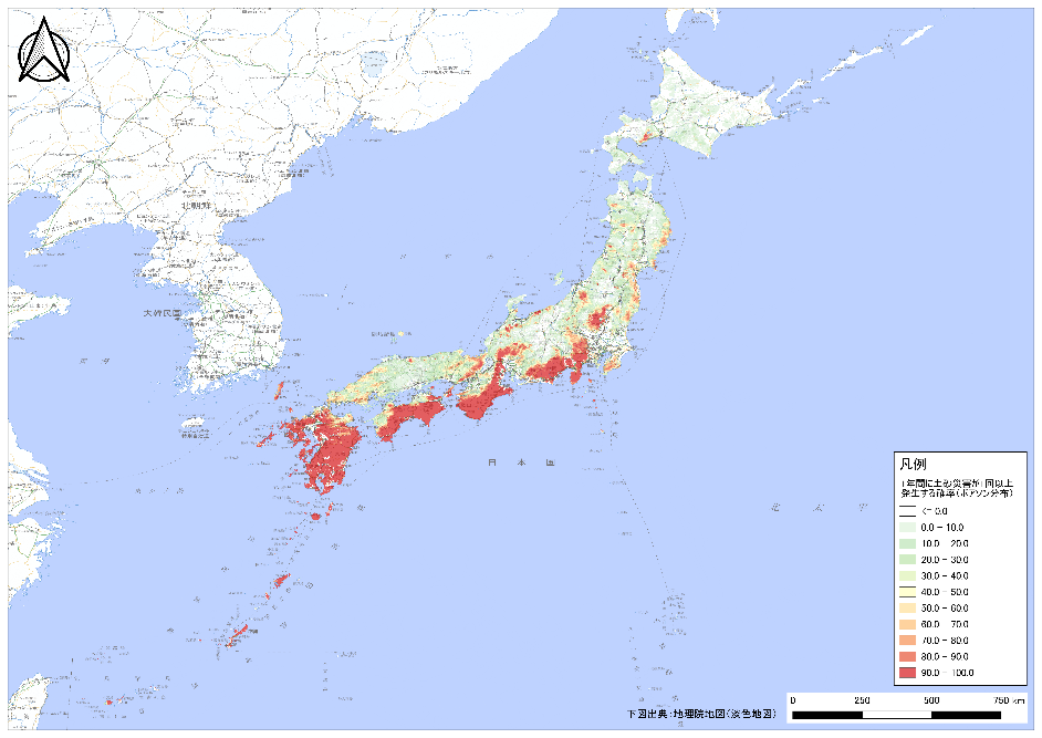
The Japan Meteorological Agency's Dosha Kikikuru (risk distribution of heavy rain information (landslide disasters)) can help you understand the increased risk of landslides caused by heavy rain, but it does not tell you how often heavy rain that causes landslides occurs during peacetime. Therefore, in order to raise awareness of landslide risks during peacetime, we have developed the Doshaburu Risk Assessment Map, a landslide risk assessment map based on uniform nationwide indicators.
[Overview and Features of the Doshaburu Risk Assessment Map]
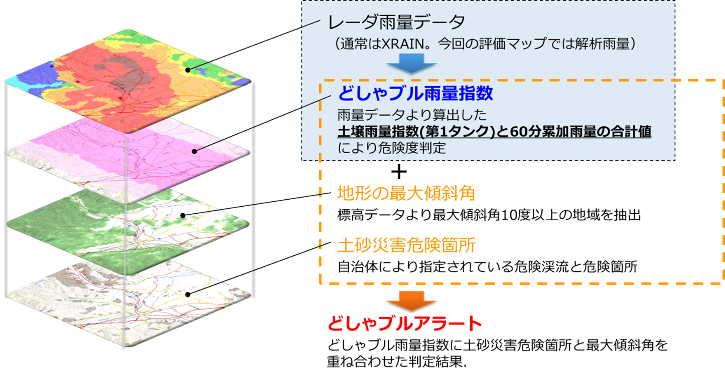
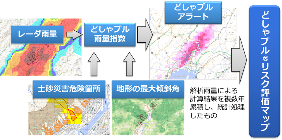
(1) Using the Doshaburu Rainfall Index developed by PACIFIC CONSULTANTS CO., LTD., 15 years of analyzed rainfall data (Japan Meteorological Agency) from 2006 to 2021 was analyzed.
(2) Visualization of how frequently heavy rainfall causing landslides occurs in a year
(3) By overlaying the data on landslide hazard zones, it is possible to grasp the risk of landslide disasters from both the perspectives of topography and precipitation.
(4) It is also possible to evaluate mountainous areas that are not designated as landslide hazard areas.
■About Landslide Hazard Information Service”DosyaburuⓇ”:https://xrain.pckk-service.jp/dosyabull/storeLink/
■About ”Shirabel®” - the risk diagnosis system:https://xrain.pckk-service.jp/RiskMap/
■Research paper on "DosyaburuⓇ Risk Rainfall Assessment Map::
Takahiro IGARASHI, Hiroshi TAKEBAYASH, Hirotaka HAMADA, Yosuke TSURUTA, Nagio ITO, Sota FUTAGI, Arisa TANAKA and Yusuke UEMURA: Evaluation index of risk of landslide occurrence using landslide rainfall index by analytical rainfall, Journal of JSCE B1 (Hydraulic Engineering) Vol. 78, No. 2, I_373-I_378, 2022.
■For inquiries regarding this article.
PACIFIC CONSULTANTS CO., LTD.
3-22 Kanda-nishikicho, Chiyoda-ku, Tokyo 101-8462, Japan
Contact: IGARASHI, Disaster Prevention Business Dept.
TEL 03-6777-1545
E-mail:dosya-bull@ss.pacific.co.jp
MS&AD InterRisk Research & Consulting, Inc.
Watellus Annex, 2-105 Awaji-cho, Kanda, Chiyoda-ku, Tokyo 101-0063, Japan
Contact: TAKAI, Sales Promotion Dept.
TEL:03-5296-8919
E-mail:eisui_ankeito@ms-ad-hd.com