River basin-wide flood management was proposed as a flood management measure in which various stakeholders in the river basin work together to address the issue from both hard and soft perspectives. “River Basin-wide Flood Management Project" has also begun. However, because there are so many stakeholders involved and the measures are so wide-ranging, some have expressed that it is difficult to see exactly how collaboration should take shape, which measures should be prioritized, and what the expected outcomes will be. To understand how to overcome these challenges and move toward full-scale implementation, we have asked four peoples at PACIFIC CONSULTANTS: Ryoji HIRAKAWA, a Chief Technical General Manager, who leads the river basin-wide flood management initiative; Shogo NAGAO from Urban Management Sec., Transportation Planning Dept., Social Innovation Div.; Haruka SUZUKI from the Regional Flood Management Planning Sec., River Basin Planning Dept., Land Infrastructure Div.; and Hiroaki MAEDA from the DS Promotion Sec. and Resilience Promotion Sec., Disaster Prevention Dept. Digital Service Div.
INDEX
- Why is “river basin-wide flood management” now?
- Why is river basin-wide flood management so hard to make progress?
- Approaches to promoting river basin-wide flood management
- Approach (1): Evaluate the integration of the flood control measures and urban development
- Approach (2): Support businesses by refining hazard maps
- Approach (3): Enhance the countermeasures based on individual risk assessment and improve regional functions and value
- What PACIFIC CONSULTANTS can do
Why is “river basin-wide flood management” now?
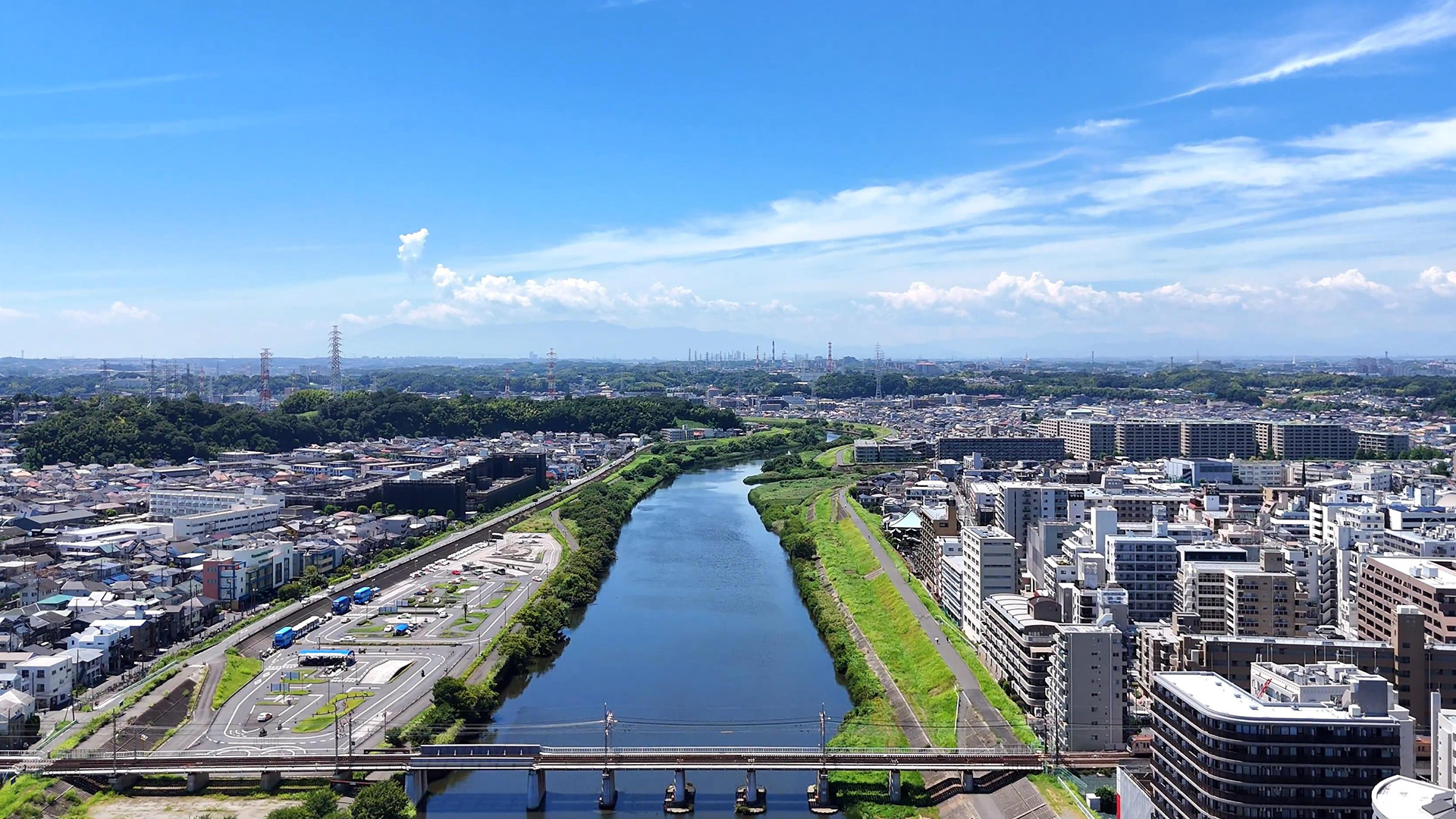
The shift away from traditional flood management—which was led by river management authorities and focused on hard perspective—is driven by the increasing severity and frequency of flood disasters associated with climate change. According to data from the Japan Meteorological Agency, looking solely at rainfall patterns, the number of short-time heavy rain occurred cases—defined as those with hourly rainfall exceeding 50 mm—averaged 226 per year during the 10-year period from 1976 to 1985, but rose to 334 per year during the 10-year period from 2015 to 2024, an increase of approximately 1.5 times. It is expected that damage will continue to worsen in the future due to increased precipitation resulting from rising sea surface temperatures caused by global warming, as well as larger typhoons.
Furthermore, flood damage is becoming more complex and severe. For example, heavy rainfall on slopes loosened by earthquakes can cause numerous landslides, leading to many debris flow that send large amounts of soil and driftwood debris downstream, destroying bridges, levees, and even buildings. In some cases, this develops into secondary disasters, such as damage to power plants and water and sewage facilities, paralyzing urban functions.
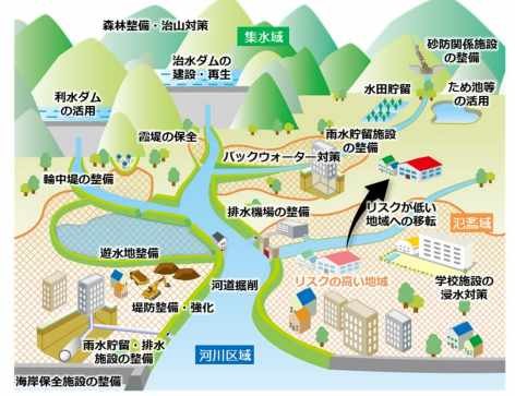
Against this backdrop, the national government has made a major shift in its approach to flood management. It has shifted its focus to “river basin-wide flood management,” which involves considering flood management measures across the entire river basin—including not only the watersheds and river zones but also downstream floodplains—and is implementing three main strategies in an integrated, multi-layered manner that combines hard and soft perspectives measures, tailored to regional characteristics: (1) prevent and reduce flooding as much as possible, (2) reduce the number of affected areas, and (3) mitigate damage and facilitate early recovery and reconstruction.
Source: “Basic Concepts of River Basin-wide Flood Management” (Ministry of Land, Infrastructure, Transport and Tourism)
Why is river basin-wide flood management so hard to make progress?
No one disputes that future flood control measures must be a concerted, all-out effort involving the entire watershed. However, there are many challenges, and progress on these initiatives has been slow. One issue is that the scope of the work is extremely broad, involving a wide range of stakeholders—including the national government, prefectures, municipalities, private companies, and residents—and requiring a variety of measures. Another challenge is the lack of clarity regarding who is responsible for what, how the various measures should be coordinated, and what effects these measures will ultimately have on the river basin. In particular, there is insufficient accumulated experience regarding measures for damage mitigation and early recovery and reconstruction in floodplains—areas where new measures are now required in addition to traditional watersheds and river zones. There is a lack of know-how regarding the development and implementation of core technologies, and the necessary measures, their expected effects, and the specific benefits for the local governments, companies, and residents involved remain unclear.
Approaches to promoting river basin-wide flood management
Approach (1): Evaluate the integration of the flood control measures and urban development
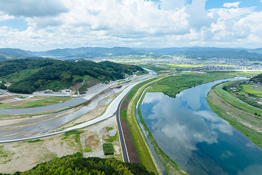
For example, "relocation to low-risk land" is said to be a promising option. However, for local governments, urban development challenges are not limited to flood control. While anticipating population decline and an aging society with a low birthrate, there are many challenges from the perspective of sustainable urban development, such as how to promote the revitalization of central urban areas, the development of industries, the maintenance of daily living environments, the stable provision of education, medical and nursing care services, and the securing of safe means of transportation. Prioritizing only flood control may make it more difficult to solve other problems. By implementing policies that combine flood control and urban development, a positive cycle that is effective for both flood control and urban development must be created. To achieve this, it is necessary to quantitatively evaluate the effects from a cross-sectoral perspective that includes not only flood control but also urban development.
Approach (2): Support businesses by refining hazard maps
In order to promote “river basin-wide flood management” in floodplains, private real estate developers and housing companies have a significant role to play in developing land that is resilient to flooding and providing housing on such sites. However, private-sector initiatives in this area have not progressed very far. This is because a viable business model has not yet been established, and the benefits of investment are not apparent. Currently, the industry’s understanding is limited to checking whether a plot of land is designated as a landslide warning zone on hazard maps; if it is, developers abandon the project, assuming the homes would not sell. They have not yet been able to translate this information into company-specific initiatives that enhance the value of the land and buildings.
However, if, for example, a real estate developer can perform a detailed simulation of the risk of landslides on land they own, it will lead to a more precise representation of publicly available hazard maps. Knowing how much rainfall will cause slope collapses, where and how they will occur, and how the resulting debris flows will spread will allow for measures such as land development and zoning, the location and direction of fences, the creation of green spaces, and the design of evacuation routes. Even if a property is located within a warning zone on a hazard map, it is possible to mitigate risks and increase the value of the land through unique measures. Furthermore, in residential design, by utilizing engineering knowledge such as hydraulics to devise construction methods and strengthen specifications to create flood-resistant homes that take into account the risk of flooding and landslides on the land, it becomes possible to provide homes that are resistant to all hazards, including earthquakes, fires, floods, and landslides, offering higher value and leading to new business opportunities.
If we can combine civil engineering and architecture based on detailed disaster risk simulations to advance land use and enhance the value of buildings, we can turn flood countermeasures into a means of strengthening business, which will serve as a major incentive for private companies to participate in the river basin-wide flood management initiative.
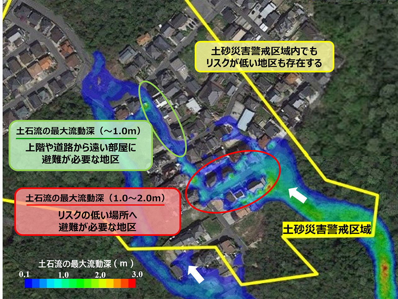
Created by our company based on existing materials (provided by Professor TAKEBAYASHI of the RiSM Research Dept., Kyoto University).
Approach (3): Enhance the countermeasures based on individual risk assessment and improve regional functions and value
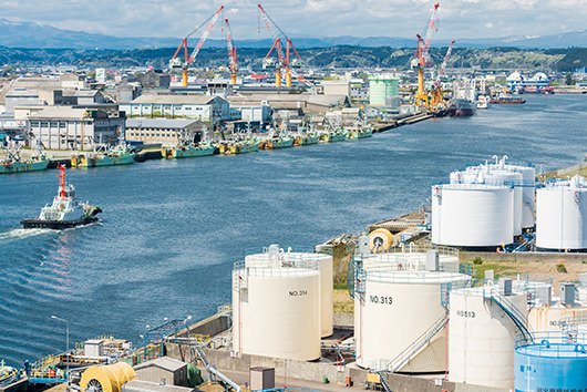
The river basin-wide flood management ’s initiatives in floodplains aim to reduce flood risk across the entire region, including floodplains, and a key challenge within this context is how to protect core factories and large-scale business sites. The impact of flooding is not limited to a single company; if operations are suspended for an extended period, the effects can ripple through the supply chain to affect surrounding small and medium-sized enterprises and the local economy, potentially causing widespread damage. However, despite the nationwide development of hazard maps and other publicly available information by government agencies, these resources have not sufficiently translated into concrete countermeasures. This is largely because hazards are not being assessed as “risks,” preventing them from informing specific countermeasures or investment decisions.
For example, when dealing with a complex of buildings with different functions and equipment configurations, it is essential to identify where the vulnerabilities in the facilities lie. Furthermore, only by understanding how these vulnerabilities will affect production lines as flooding progresses can we clearly define the priorities for realistic countermeasures and the scale of investment required.Conducting such risk assessments at the individual facility level makes it possible to set goals—such as “what scale of flooding to prepare for” and “to what extent to ensure business continuity”—and to specify the measures necessary to achieve them. Implementing these measures not only enhances the company’s own business continuity but also helps reduce damage across the entire region, serving as a key factor in enhancing the effectiveness of the river basin-wide flood management.
Furthermore, developers undertaking redevelopment projects in specific districts within the city center also play a major role as key players in river basin-wide flood management. Addressing river basin-wide flood management is not merely a matter of disaster response; it is a business challenge that determines the profitability and competitiveness of development projects. In recent years, there has been an increasing number of cases where flood risk influences real estate valuations, tenant selection, and investment decisions; whether future risks are appropriately factored in determines the competitiveness of a development project. Therefore, if these risks can be properly identified and visualized, the prioritization of countermeasures and the accuracy of investment decisions will improve significantly. By analyzing the progression of flooding over time and clarify “at what rainfall intensity and from where flooding will occur” and “which facilities or spaces will act as bottlenecks,” it becomes possible to implement reasonable countermeasures that are neither excessive nor insufficient. Specifically, this can lead to the following business benefits:
- Advanced preventative measures during the design phase (optimization of equipment placement, water stoppage plans, etc.)
- Strengthening tenant attraction by adding safety as a value proposition
- Improving our ability to explain our policies to investors through compliance with ESG and SSBJ *
- Maintaining and improving asset value while incorporating future risks
* ESG standards established to strengthen sustainability information disclosure by Japanese companies.
Furthermore, sharing countermeasures that take into account the risks across the entire district with stakeholders facilitates cost-effectiveness-based consensus building, directly leading to faster and more sophisticated decision-making in large-scale redevelopment projects.
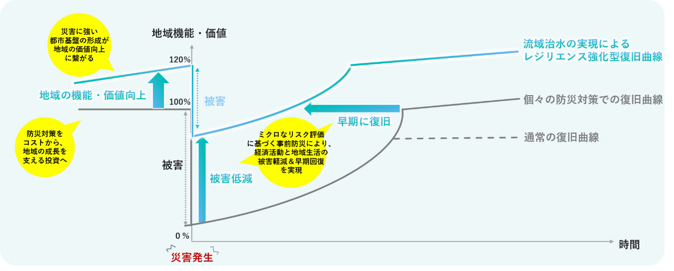
The accumulation of sophisticated countermeasures based on such micro-level risk assessments will ultimately lead to the formation of disaster-resilient urban infrastructure, thereby improving the overall functionality and value of the district.
What PACIFIC CONSULTANTS can do
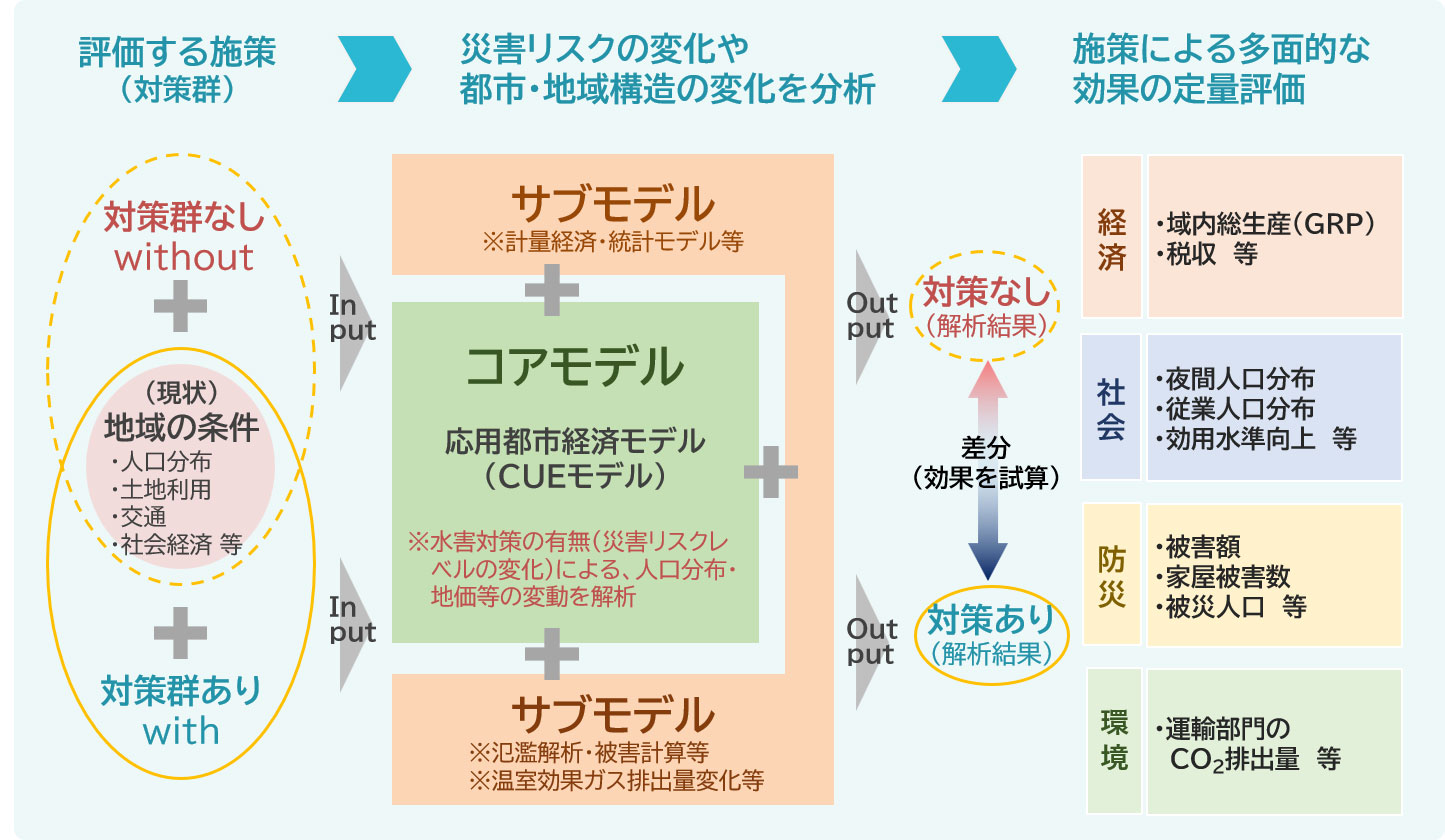
Promoting the river basin-wide flood management requires all-out effort; otherwise, it cannot be effective. There are two key points to achieving this. The first is to implement measures in a way that is consistent with the long-term goal of creating a “compact city” as part of sustainable urban development. The second is to expand the scope of stakeholders in the “river basin-wide flood management” initiative from the government alone to include the private sector. Without these two elements, river basin-wide flood management cannot be realized. To that end, what is most urgently needed now is the establishment and utilization of a methodology for selecting the city’s future direction through multifaceted, quantitative evaluation of the effectiveness of various measures, as well as the establishment of a business model that encourages the active participation of private companies in river basin-wide flood management.
PACIFIC CONSULTANTS with a 75-year history as a comprehensive construction consulting firm, we have been at the forefront of developing a “method for quantitatively evaluating the multifaceted effects of a set of measures” by leveraging the applied urban economic model we have refined through our work in the field of transportation planning, as part of our efforts toward the new river basin-wide flood management. The Applied Urban Economic Model is designed to analyze, predict, and evaluate the impact of urban and transportation policies on urban structure. By applying this model, we aim to quantitatively evaluate the effects—not only in terms of flood risk reduction but also in various other aspects such as urban development, the economy, industry, and the environment—that result when flood control measures are implemented in conjunction with urban development initiatives (such as the promotion of residential and industrial activities). This flood control measures make it possible to clarify the value that these measures hold as part of urban development, leading directly to EBPM (Evidence-Based Policy Making)—that is, the formulation of urban development policies based on objective data.
Furthermore, by applying the detailed flood simulation technology cultivated in the river management field to floodplains, we are now able to conduct detailed inundation analyses of residential areas, factories, and buildings. We are already conducting concrete discussions with many local governments, companies operating large-scale factories, real estate companies developing land, and developers working on urban development in prime locations in the city center, on how to minimize damage in floodplains.
Furthermore, we are considering in partnership with home builders to develop and brand homes that are resistant to all kinds of disasters, including not only earthquakes and fires but also floods.
The river basin-wide flood management is only possible through cross-disciplinary collaboration. We believe that PACIFIC CONSULTANTS can serve as a hub, leveraging its comprehensive strengths across a wide range of technical fields. Already, our young, next-generation engineers are passionately and proactively applying cutting-edge technologies with flexible thoughts, driving initiatives that go beyond the scope of a typical construction consulting firm. Moving forward, we will continue to collaborate with all stakeholders active in the river basin to further advance the river basin-wide flood management.