In recent years, there have been many landslides caused by short periods of heavy rain, and the number of casualties per disaster has been on the rise. Protecting corporate employees, their families, facilities, and factories from landslides is a major issue for business continuity. However, when it comes to deciding specifically where to start, many people say they don't know where to start. We spoke with Takahiro Igarashi, who is in charge of supporting companies in formulating disaster prevention plans, business creation, and the development and operation of the landslide information service "Doshaburu®" in the Disaster Disaster Prevention Dept. of PACIFIC CONSULTANTS 'Digital Service Div. Headquarters, and Tatsuki Hirano of the Resilience Promotion Office in the same department.
INDEX
- Landslides continue to increase, with damage spreading to infrastructure facilities
- Classification of landslides
- Issues in landslide prevention measures
- Strengthening soft aspects is key to landslide prevention measures
- PACIFIC CONSULTANTS' landslide prevention services
Landslides continue to increase, with damage spreading to infrastructure facilities
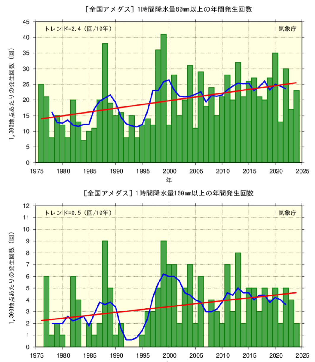
The number of landslides is clearly increasing. Ministry of Land, Infrastructure, Transport and Tourism announced that there will be 1,433 landslides in 2024. This is much higher than the average number of landslides per year between 1982, when statistics began, and 2023, which was 1,108. Moreover, as many people have realized, unprecedented heavy rain has started falling in various places. Rainfall of more than 100 mm per hour used to be extremely rare, but it is not uncommon these days. This is also clearly reflected in the numbers, with the average number of landslides per year being about 2.2 times in the first 10 years since statistics began (1976-1985), but about 4.0 times in the most recent 10 years (2015-2024), a 1.8-fold increase.
In addition, as these heavy rains become more frequent, sediment that has run off upstream accumulates in the middle and downstream areas, raising the riverbed, and the combination of sediment and floodwaters causes flooding, which is known as "landslide and flooding." Landslide and flooding not only endangers the lives of residents, but also causes great damage to infrastructure facilities such as roads and railways, and has long-term effects on local social and economic activities. Furthermore, if sediment accumulates widely in urban areas, rescue and recovery efforts will be hindered, and the effects will be long-lasting.
Classification of landslides
There are three types of landslides. A slope close to the surface of the ground becomes loose due to rainwater infiltration or earthquakes, causing it to suddenly collapse. A landslide is when part or all of a slope slowly moves down due to the influence of groundwater and gravity. A debris flow is when stones and soil on a mountainside or riverbed are swept downstream in one go by prolonged rain or heavy rain. Landslides account for about 70% of all landslides, but in both cases, they occur when heavy rain falls on areas where a lot of rain has accumulated underground. The Landslide Prevention Act, which was partially revised in 2010, requires prefectural governors to designate areas at risk of landslides as landslide warning areas or special landslide warning areas and take necessary measures. As of December 31, 2024, there are 698,721 landslide warning areas nationwide (600,462 of which are special landslide planning areas).
|
Definition |
Roles and Restrictions of Wards, Cities, Towns and Villages | |
|---|---|---|
|
Landslide hazard zone |
An area deemed to be at risk of harm to the lives or bodies of residents in the event of a landslide, and is set taking into consideration the reach of sediment from past landslides. |
Wards, cities, towns, and villages must stipulate in their local disaster prevention plans the collection and transmission of information regarding landslides, the issuance and transmission of forecasts or warnings, rescue and other necessary alert and evacuation systems. Ward, city, town, and village mayors must distribute hazard maps and other printed materials containing information necessary for alert and evacuation, and make it known to residents. In addition, in real estate transactions, real estate agents must provide and explain important matters, stating that the area is a landslide risk zone. |
|
Special landslide hazard zone |
An area designated as a landslide hazard zone where it is deemed that if a landslide occurs, there is a risk of damage to buildings and serious harm to the lives and bodies of residents. |
In addition to being carried out in landslide-prone areas, a permit system will be required for certain development activities and structural restrictions will be put in place for buildings. |
Issues in landslide prevention measures
As the number of landslides is on the rise, there is a need to step up vigilance to ensure the safety of residents' lives and the continuation of business activities, but preparing for landslides can be quite difficult. One reason for this is that the imminence of a disaster is invisible. When a river floods, the water level rises with every passing moment, so it is clear to everyone that there is an imminent danger. However, it is not possible to see how much water has seeped into the soil. This causes people to not feel a sense of danger, and they end up waiting to see what happens until the very last moment.
Another reason why landslide prevention measures are difficult is the difficulty of taking hard measures. In the case of flood prevention measures, it is possible to identify areas where flooding is expected and prepare waterstops and sandbags. However, once a landslide occurs, it is large-scale, and it is not easy to stop the damage around company buildings and facilities. Large-scale civil engineering work is often required near the source, and there are limits to what a company can do alone. Therefore, as a basic measure, when building or relocating a company facility, the first thing to do is to check whether the proposed site is a landslide warning zone or special warning zone on a hazard map and avoid it. However, the designation of warning zones is for the safety of people and the protection of assets, and mountainous areas where no people live may be excluded from the designation even if a disaster is expected to occur. If you are planning to install power transmission or communication facilities in mountainous areas, you should be aware that hazard maps may not be sufficient as a prior confirmation. Other landslide prevention measures that companies may consider in terms of hard measures include repairing the areas around openings to minimize the inflow of soil and sand, and reinforcing the structure to prevent the collapse of buildings. It is also effective to store important assets as far away from cliffs as possible, and to store or install them on the second floor or higher of reinforced concrete buildings.
Strengthening soft aspects is key to landslide prevention measures
Given that it is difficult for a company to implement hard countermeasures against landslides on its own, an effective measure to protect its own facilities and employees from landslides is to improve soft countermeasures both in peacetime and when a disaster is imminent.
First, in peacetime, we strengthen the information gathering system for the approach of heavy rain, identify dangerous areas around company facilities, and identify dangers around employees' homes and commuting routes. With such preparations, we can get a more concrete understanding of the imminence of a landslide disaster, and can quickly give instructions such as leaving work early or waiting at home using safe routes and means, and can patrol facilities early.
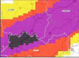
In addition, when a landslide is predicted to occur, you can check the Landslide Kikikuru danger level distribution published by the Japan Meteorological Agency and decide what actions to take based on the indications of "Caution" (yellow), "Alert" (red), "Danger" (purple), or "Imminent Disaster" (black).
The landslide risk distribution map shows the increasing risk of landslides caused by heavy rainfall in five different colors for each 1km square area (mesh). It is updated every 10 minutes.
In addition, when a landslide is deemed imminent, prefectures and the Japan Meteorological Agency will jointly identify affected municipalities and issue "Landslide Hazard Information." This serves as a guideline for local governments when issuing evacuation orders to residents. It is issued at the stage equivalent to the "Danger" (purple) level on the Kikikuru, and is issued when it is predicted that the criterion will be reached within the next two hours, taking into account the time it will take to evacuate. When a landslide warning is issued, you can check the specific locations where the danger is increasing by looking at the Landslide Kikikuru.

PACIFIC CONSULTANTS' landslide prevention services
When it comes to landslide prevention, it's important to grasp the urgency of the disaster as quickly and specifically as possible, and then take the necessary action. Yahoo! Weather & Disasters and Weathernews are well-known apps for raincloud radar information. Many people already use them on their smartphones. However, PACIFIC CONSULTANTS felt there was still room for improvement in disaster prevention information apps for landslides. Prior to developing Kikikuru, the company began developing its own app in 2015, releasing the mobile app "Doshaburu®" in 2017. Based on the concept of being "easy to understand, easy to obtain, and usable at any time," the app aims to "enable people to obtain the information they need about rain and landslides at the time and place they need it."
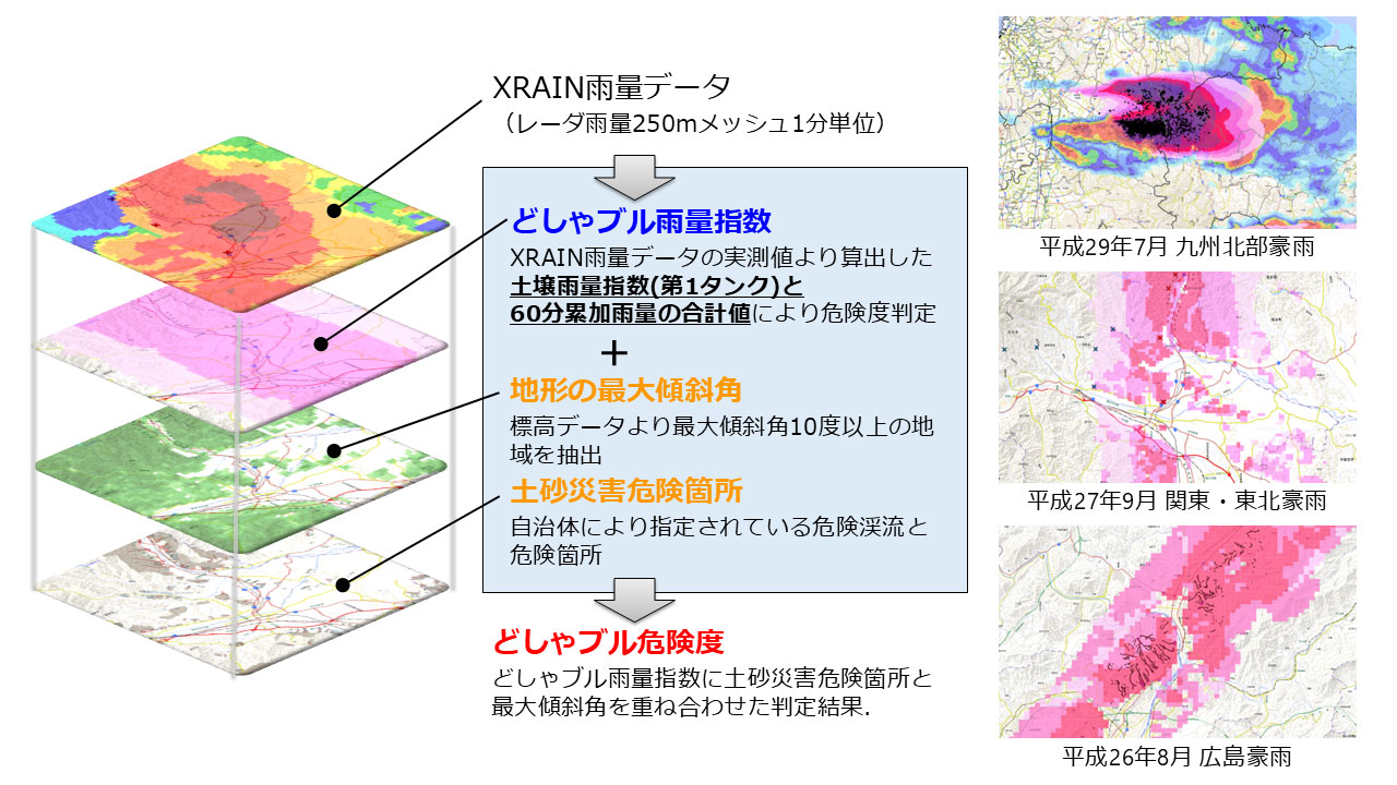
A major feature of "Doshaburu®" is the high accuracy of the rain information it provides. By utilizing XRAIN, operated by Ministry of Land, Infrastructure, Transport and Tourism, observations can be made at a higher frequency (5 times) and at a higher resolution (16 times) than conventional radar known as C-band radar. Specifically, information can be obtained every minute on a 250-mesh grid, and the time required for distribution has been reduced to around 1 to 2 minutes.
|
C-band radar |
XRAIN |
|
|
Minimum observation area |
1km mesh |
250m mesh |
|
Delivery cycle |
5 minutes |
1 minute |
|
Delivery time |
About 5-10 minutes |
About 1-2 minutes |
Doshaburu® also uses a unique method to combine the soil rainfall index (first tank) calculated using this highly accurate rainfall data with the total value of 60-minute cumulative rainfall, as well as data on the maximum slope of the terrain and areas at risk of landslides, to provide a function to search for rainfall at the current location and registered locations, and to check whether it will be raining at the destination in x minutes.It also independently determines the risk of landslides occurring at the current location and registered locations, and displays this on a five-level map while issuing an alert.
Another feature of "Doshaburu®" is its user-friendly and user-friendly interface. By making it easy to grasp accurate rainfall information on a daily basis, it also helps to foster and increase vigilance against rainfall and landslide disasters.
In addition, the paid "Doshaburu® Pro" can be used on a PC web browser and allows you to register multiple locations at once (no limit on the number of locations), determine the risk level at all registered locations, and review the rainfall conditions and risk level assessments from past heavy rains. Not only can it be used to avoid danger for workers who are late in evacuating during heavy rain, to avoid danger during patrols such as road closures, and to quickly grasp the status of landslides, it is also extremely effective as a means of obtaining reference and supplementary information when government agencies issue risk information.
In addition to "Doshaburu®," PACIFIC CONSULTANTS has also developed the app "Shirabell®," which allows users to pinpoint a wide range of natural disaster hazard and risk information from an address or map screen. Not only can anyone easily learn about disaster risks, but they can also obtain a "risk diagnosis report," allowing them to prepare for various risks on a daily basis.
PACIFIC CONSULTANTS will continue to provide various support in preparation for landslide disasters.