The Kumamoto Earthquake in April 2016 was unprecedented in recorded history, with two magnitude 7 tremors occurring within 28 hours. Nishihara Village in Kumamoto Prefecture, located near the epicenter, suffered extensive damage. PACIFIC CONSULTANTS became involved early in Nishihara Village's disaster restoration efforts, providing ongoing support for the regeneration of six villages, focusing on both earthquake-resistant land development and urban planning. Shunichiro KANEKO from the Geotechnical Disaster Prevention Sec., Geotechnical Engineering Dept., Land Infrastructure Div. and Hiroto YAMAGUCHI from the Integrated Project Sec., Social Innovation Dept., Kyushu Headquarters, who played a central role in the project, reflected on their work.
Overview of Damage of Nishihara Village Caused by the Kumamoto Earthquake 2016
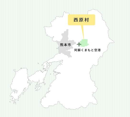
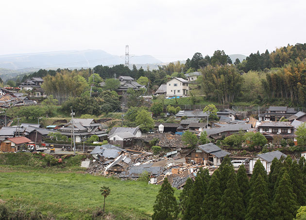
Nishihara Village is a village with a population of approximately 7,000 located about 20 km east of Kumamoto City in the central part of Kumamoto Prefecture. To the east, vast plains and forests spread out, centered around Mt. Tawarayama, which is part of the outer rim of the Aso caldera. The village was hit by earthquakes on April 14th and 16th, 2016, with tremors of magnitude 6-minus and magnitude 7 respectively, resulting in 5 deaths, 4 related deaths, 512 houses completely destroyed, 201 severely damaged, 664 partially damaged, and approximately 56% of houses that underwent damage assessment surveys suffered damage of partial damage or worse. (Figure as of April 2023).
<Foreshock> Around 9:26 PM on April 14th, epicenter depth 11 km, magnitude 6.5
Seismic intensity 7: Mashiki Town; Seismic intensity 6- (weak): Higashi Ward, Nishi Ward, Minami Ward of Kumamoto City, Nishihara Village, and others.
<Main Shock> Around 1:25 AM on April 16th, with a focal depth of 12 km and a magnitude of 7.3.
Seismic Intensity 7: Mashiki Town, Nishihara Village
Source: Nishihara Village Disaster Archive, "Damage from the Kumamoto Earthquake"
INDEX
- Six villages located on top of a fault zone
- Exploring the potential of utilizing national subsidy programs
- Earthquake-resistant residential land using landslide prevention projects
- Considering how to revitalize the village
- Proceeding with the detailed design and holding residents' briefing session
- Also conducting study tours to areas that are leading the way in community development
- The population of Nishihara Village has increased compared to before the earthquake
Six villages located on top of a fault zone
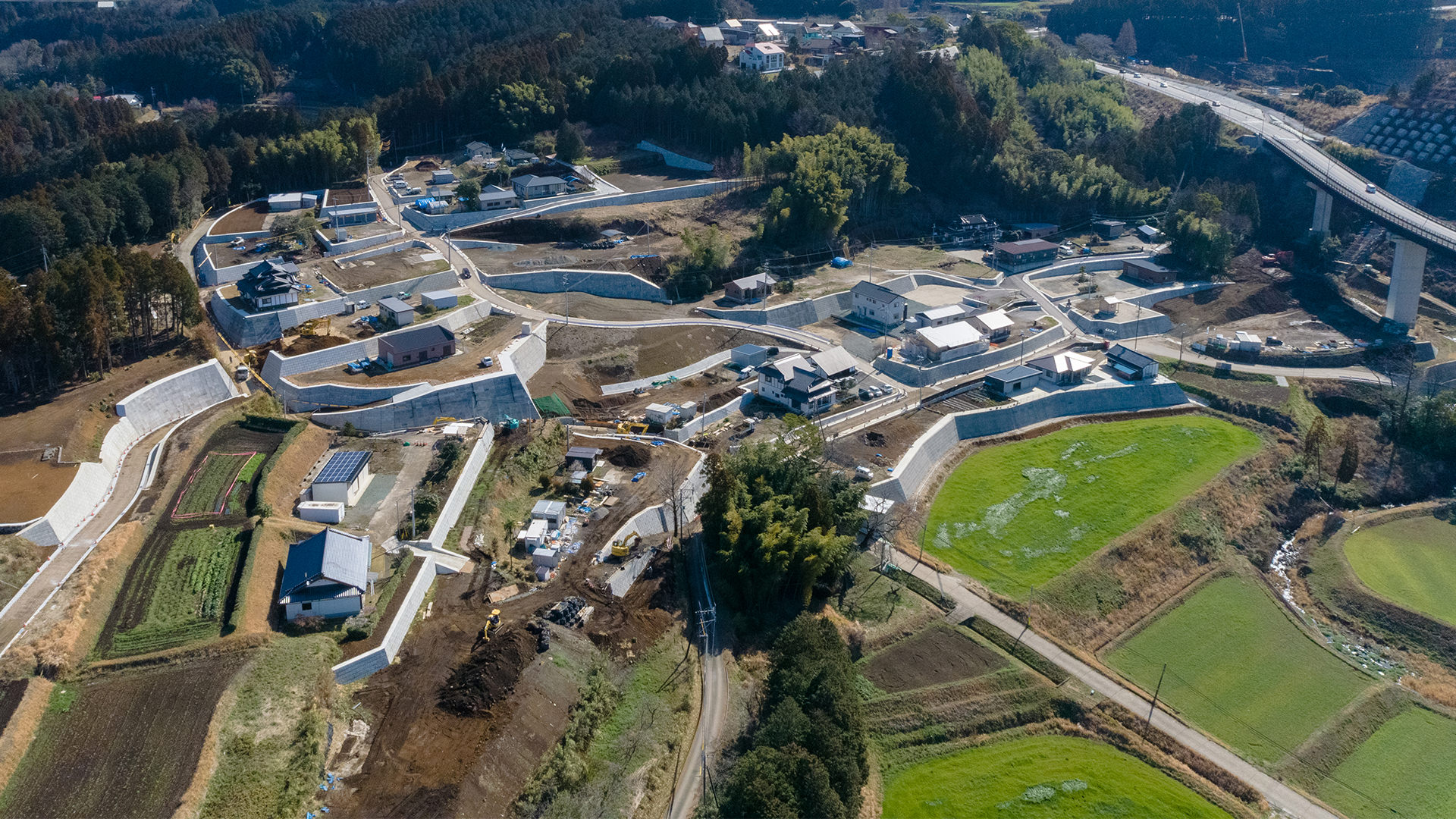
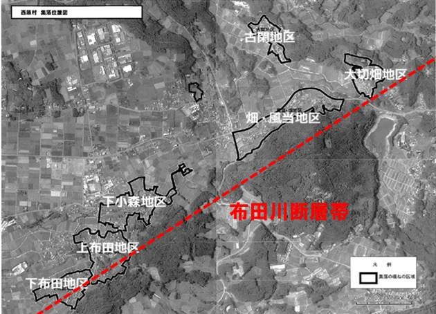
The seismic activity area of the Kumamoto Earthquake had two fault zones located close together: the Futagawa Fault Zone and the Hinagu Fault Zone. The National Earthquake Research Committee analyzed that the M6.5 foreshock was caused by the activity of the Hinagu Fault Zone, and the M7.3 main shock was caused by the activity of the Futagawa Fault Zone. Nishihara Village, being close to the Futagawa Fault Zone, was hit by severe shaking, resulting in numerous road collapses, ground fissures, and landslides. Approximately 23% of the houses in the village were completely destroyed, and about 56% were partially or completely destroyed. In particular, the six villages of Koga, Taisetsuhata, Hata/Kazeto, Shimokomori, Kamifuta, and Shimofuta, which are located along the fault zone, suffered what could be described as catastrophic damage.
Provided by Nishihara Village
Restoration and reconstruction efforts began immediately, with the national government providing support through liaison officers, tech forces (emergency disaster response teams), and the Self-Defense Forces. In addition, dozens of officials dispatched from Higashimatsushima City, Ishinomaki City, Natori City, and Wakuya Town, areas affected by Great East Japan Earthquake provided advice on initial response organization and waste disposal, and also assisted in conducting surveys of housing damage.
Exploring the potential of utilizing national subsidy programs
PACIFIC CONSULTANTS also began providing support immediately after the disaster. The first to head to the site was Geotechnical Engineering Dept. of Land Infrastructure Div.. In Nishihara Village, there were many wooden houses built over 40 years ago under the old seismic standards, and the severe shaking caused retaining walls to collapse, as well as numerous ground subsidence, uneven ground, and sinkholes, resulting in extensive damage to houses. Preventing ground landslides and repairing and maintaining retaining walls are essential for reconstruction. In May, Geotechnical Engineering Dept. established a reconstruction office in Kumamoto, gathering engineers from Hokkaido, Tohoku, Tokyo, Osaka, and Kyushu. KANEKO was one of them. "We went to the site during Golden Week in May. There were still collapsed houses remaining, but we had to rush the investigation of the ground and retaining walls. We knew from our experience with the Great East Japan Earthquake that we needed to investigate how the buildings had collapsed and whether they could be restored, and if so, how to repair them specifically. The local government had also started working on it, but there were too many buildings to investigate and not enough engineers. So we started by helping out other municipalities besides Nishihara Village," said KANEKO.
Following the efforts of Geotechnical Engineering Dept. our company will now be fully involved in the villages revitalization project in Nishihara Village. YAMAGUCHI from the Integrated Project Sec. reflects on the initial efforts.
"The damage was immense, and reconstruction will be a project that will take several years. However, unlike Great East Japan Earthquake there are no reconstruction grants or special tax measures in place. We had to work while utilizing existing national subsidy programs and systems. Specifically, we anticipated that we could use two programs: the 'Large-scale Embankment Construction Site's Slide and Collapse Prevention Project' and the 'Small-Scale Residential Area Improvement Project.' However, it was necessary to allocate the areas to be restored to these two projects in order to meet the subsidy requirements. We utilized our various elemental technologies and knowledge to allocate the projects and consider applying for subsidies in order to receive the maximum amount of support from the government."
Earthquake-resistant residential land using landslide prevention projects
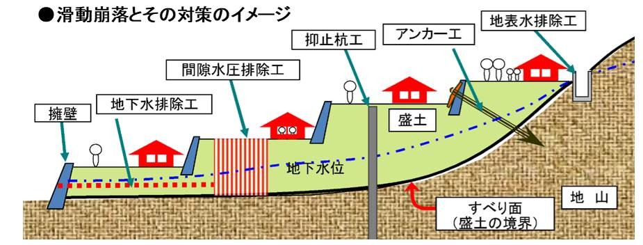
The "Large-scale Embankment Construction Site's Slide and Collapse Prevention Project" is a program in which the government provides subsidies for the development of residential land, and if certain conditions are met, the government will provide a portion of the restoration costs. KANEKO explains.
Source: Large-scale Embankment Construction Site's Slide and Collapse Prevention Project (Ministry of Land, Infrastructure, Transport and Tourism)
"Unlike roads and other public infrastructure, residential land is private property, so normally, national funds are not used for its maintenance. However, the damage was so extensive that it would be impossible for individuals to bear the cost of repairs alone. This system provides national support to prevent future damage. We had been conducting basic surveys since immediately after the disaster, and based on those, we prepared detailed application documents. Once this application is approved and the budget is secured, we can finally begin concrete surveys and design work for the repairs."
However, designing the landslide prevention work that began after the application was submitted was not easy. "The soil in Nishihara Village is mainly volcanic ash soil deposited by past eruptions of Mount Aso. Volcanic ash soil is vulnerable to rain and its strength decreases when shaken. First, we deliberately shook the soil in an indoor test to reduce its strength, and then we used that data to carefully consider how much soil improvement was necessary and designed the structure accordingly," says KANEKO.
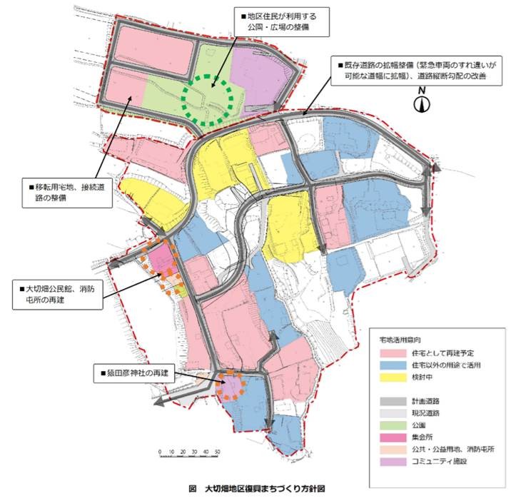
Considering how to revitalize the village
Alongside promoting landslide prevention projects, we also advanced initiatives for improving small-scale residential areas.

This project provides government support for the demolition of substandard housing (houses unsuitable for habitation due to inadequate structure or facilities, including those severely damaged by disasters), the construction of improved housing, and the development of public facilities such as roads and parks, as well as land acquisition. This will be a major force in the effort to create new towns, including roads and public facilities, while removing houses that have been completely or partially destroyed.
YAMAGUCHI, a member of the Integrated Project Sec.'s team who was also responsible for overall management, reflects on the experience.
"We started by holding residents' meetings in each district to hear how residents wanted to rebuild their communities. We discussed various ideas from residents, starting with how to prepare the land for rebuilding houses and which retaining walls to repair, to widening roads, rebuilding villages centers, and developing parks next to them. We held three or four discussions in each district, and after about six months, we compiled a plan for reconstructed urban development. The basic idea is 'Build Back Better,' which means not simply returning to the pre-disaster state, but creating a safer and more livable town. This has become an international guideline as part of Sendai Framework for Disaster Risk Reduction, which was established after Great East Japan Earthquake, and we proceeded with the planning while confirming that Nishihara Village also wanted to pursue creative reconstruction."
Proceeding with the detailed design and holding residents' briefing session
After completing the subsidy applications for land development including retaining walls and improvements to small-scale residential areas, we proceeded to the detailed design of each, and held resident briefings and individual explanations to landowners. Even if there is agreement on the overall plan for the district, various opinions arise when it comes to translating it into detailed design, says YAMAGUCHI.
"For example, widening a road means that the village has to provide land, which the village then purchases. However, some people were reluctant to give up even a portion of their ancestral land. We had careful discussions with the goal of creating a better community through everyone's cooperation. Regarding the retaining wall, there were requests such as, 'We want to build our house here on the property, so the entrance should be here,' or 'Can the retaining wall be moved a little further?' We incorporated these requests into the design as much as possible, and I believe this was possible because the geotechnical engineers and urban planning engineers collaborated, working on the detailed design as a unified whole, combining hardware and software. We were able to leverage our strengths as a comprehensive consultant."
Also conducting study tours to areas that are leading the way in community development
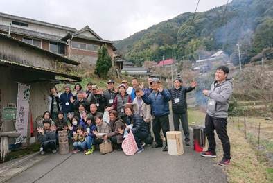
We also conducted a tour to visit a vibrant village.
Furthermore, as the detailed design progressed, YAMAGUCHI organized a site visit to a leading area for community development. The visit was well-received and attracted many participants.
"We organized a tour to visit places like Genkai Island in Fukuoka City, which suffered devastating damage in the 2005 Fukuoka Prefecture Western Offshore Earthquake but managed to bring all its residents back within three years; Koge Town in Fukuoka Prefecture, which is promoting farm stays and migration; and Itsuki Village in Kumamoto Prefecture, where young people are moving to mountainous areas and undertaking various initiatives. Everyone participated actively and gained various hints for community development, such as 'We could do something like this in Nishihara Village.' In a time when there's often a lot of gloomy news after a disaster, I think this also served as an opportunity for them to be encouraged and to keep working hard."
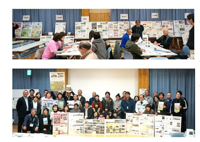
In parallel with the detailed design, we also created a record of the restoration and reconstruction efforts in each village, a village introduction booklet, and a monthly newsletter, "Villages Revitalization Newsletter," together with the residents of each village. Furthermore, we held study sessions on community development after reconstruction, which also served as a presentation of the villages' annual activities.
"Build Back Better" cannot be achieved solely through infrastructure improvements; it requires the residents' own desire to create a better town. In that sense, creating the booklet, conducting site visits, and holding study sessions proved to be of great significance.
The population of Nishihara Village has increased compared to before the earthquake
The reconstruction projects for the six villages in Nishihara Village completed detailed design for both the landslide prevention project and the small-scale housing area improvement project in 2018, two years after the disaster, and construction began sequentially. By the end of March 2021, all "Villages Reconstruction Projects," including land development and infrastructure development, were completed. KANEKO reflects:
"Although we were short on time and the workload was extremely heavy, I believe it was a very personal job. It wasn't a matter of following predetermined specifications; there were many issues that couldn't be fully addressed, and we had to deal with each one individually and find what we considered the best solution from the residents' perspective. I feel that we were able to do that to a certain extent, and it was a very fulfilling job."
YAMAGUCHI, who was involved in the overall management of the urban development project, as well as planning and design, reflects on the experience as follows:
"Disaster recovery work requires combining various elemental technologies and hardware and software initiatives to meet the diverse needs of the affected areas, leading to creative reconstruction. In that sense, I believe we were able to demonstrate our strengths as a comprehensive consultant. Personally, it was an opportunity for me to talk with each resident, consider what would be best for them, and challenge myself beyond my own expertise, including management. Civil engineering is said to be civil engineering, a technology for the citizens. This project truly reminded me of that value. I would like to utilize what I have learned in the future."
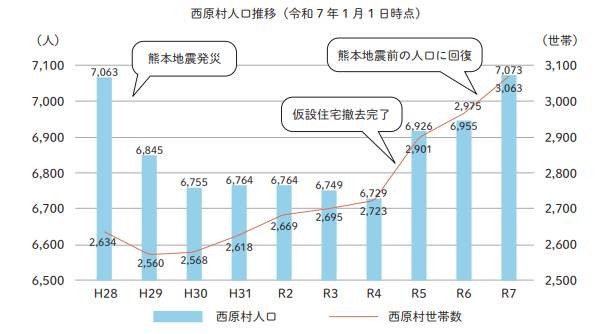
2026 marked the 10th anniversary of the Kumamoto Earthquake. The population of Nishihara Village was 7,040 at the end of March 2016, before the earthquake. Although it initially decreased significantly, it rose to 7,073 as of January 1, 2025, exceeding the pre-earthquake level. Furthermore, Nishihara Village ranked 8th nationwide in the 2025 edition of the "Best Rural Areas to Live In" ranking, conducted annually by the monthly magazine "Inaka Gurashi no Hon" (Takarajima Inc.). The earthquake-proofing of residential areas and urban development initiated as part of the post-earthquake reconstruction have since led to Nishihara Village becoming known as a place chosen for its livability.
Source: "Nishihara Public Relations" (April 2025, No. 299)