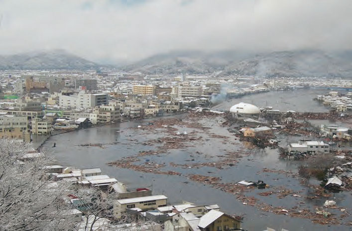
Ishinomaki City, which has long thrived as an river port centered around the former Kitakami River estuary, suffered severe damage in Great East Japan Earthquake. New embankments are essential to protect the city from Tsunamis, storm surges, and flooding. However, building new embankments in a city that has developed a unique lively atmosphere in harmony with its waterfront precisely because it lacked embankments is no easy feat. How could an embankment be constructed to protect the lives and property of residents while maintaining the close relationship between the river and their daily lives? PACIFIC CONSULTANTS was deeply involved in the restoration and reconstruction project for the former the Kitakami River estuary, a difficult challenge. Takahito AMADA from the River Structure Sec., Watershed Structure Dept., Land Infrastructure Div., and Kiyoto TSUKA from the Waterworks Sec., Hokkaido Land Infrastructure Dept., Hokkaido Branch Office who were central contributors to the project, look back on the work, which spanned more than 11 years.
Embankment planning for the former Kitakami River estuary and related projects
New embankment planning
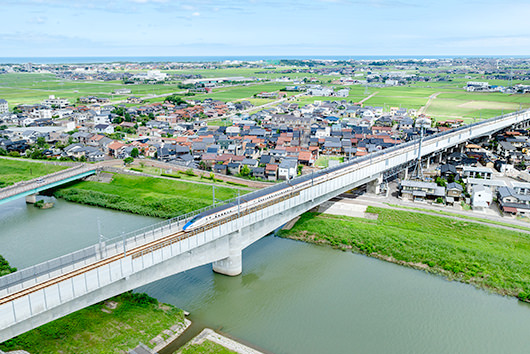
A new embankment approximately 15km long will be constructed in the no embankment section near the estuary.
・Total length: 15.0 km (embankment and revetment length: 13.8 km + training dike length: 1.2 km)
<Major related projects>
・Improvement of coastal embankments
・Improvement of Minamihama Marina, Ishinomaki Minamihama Reconstruction Memorial Park, and Nakase Park
・Replacement of Ishinomaki Kawaminato Bridge, Nishi-Nakase Bridge, Higashi-Nakase Bridge, and Utsumi Bridge
・New construction of Ishinomaki Central Drainage Pump Station, Fudosawa Drainage Pump Station, Iuchi No. 1 Drainage Pump Station, and Iuchi Drainage Pump Station
・Construction of community facilities, commercial facilities, reconstruction housing, condominiums, etc.
INDEX
- The Tsunami struck a town that had thrived in harmony with the river
- Constructing a new embankment in a historic waterfront town
- Detailed explanations at residents' information sections
- Responsible for CM work
- Creating and managing the overall project schedule
- Overseeing the entire process from design to completion
The Tsunami struck a town that had thrived in harmony with the river
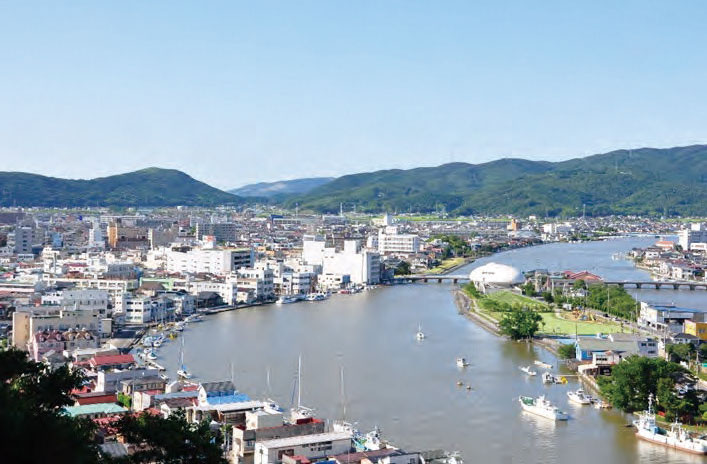
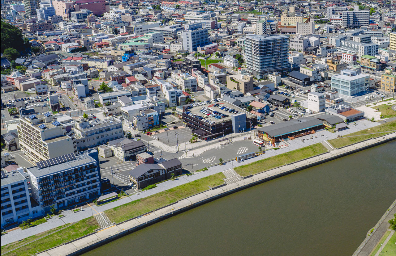
Ishinomaki City is located in the northeastern part of Miyagi Prefecture, and is the second most populous city in the prefecture after Sendai City. The central city area was built at the former estuary of Kitakami River, and since the Edo period it has prospered as a shipping point for rice sent to Sendai, Mizusawa in Iwate Prefecture, and even Edo. Over 45ton of Sendai rice was gathered in Edo Fukagawa, and it is said that it accounted for half of the rice consumed in Edo.
However, the estuary, which has long been open to the river without any embankments and where urban development had progressed in tandem with the river, suffered devastating damage from the tsunami caused by Great East Japan Earthquake. The Tsunami reached a height of 8.6m above T.P. (The reference water level of Tokyo Bay's mid-tide level), and 73km2 of the city was flooded. 3,464 people died (including those killed in the earthquake), 414 people were missing *1, and 20,044 houses were completely destroyed and 13,049 were partially destroyed *2. These figures were the highest of any city or town affected by Great East Japan Earthquake.
*1 Source: Ishinomaki City's General Affairs Dept., Crisis Management Division, as of the end of February 2023
*2 Source: Damage caused by Great East Japan Earthquake as of September 30, 2022 (Miyagi Prefecture's Reconstruction and Crisis Management Department, Reconstruction and Crisis Management General Affairs Division)
(Source: Ministry of Land, Infrastructure, Transport and Tourism, Tohoku Regional Development Bureau, Kitakami River Downstream River Office, "Efforts over 10 years since Great East Japan Earthquake (Provided by Ishinomaki City)")
Constructing a new embankment in a historic waterfront town
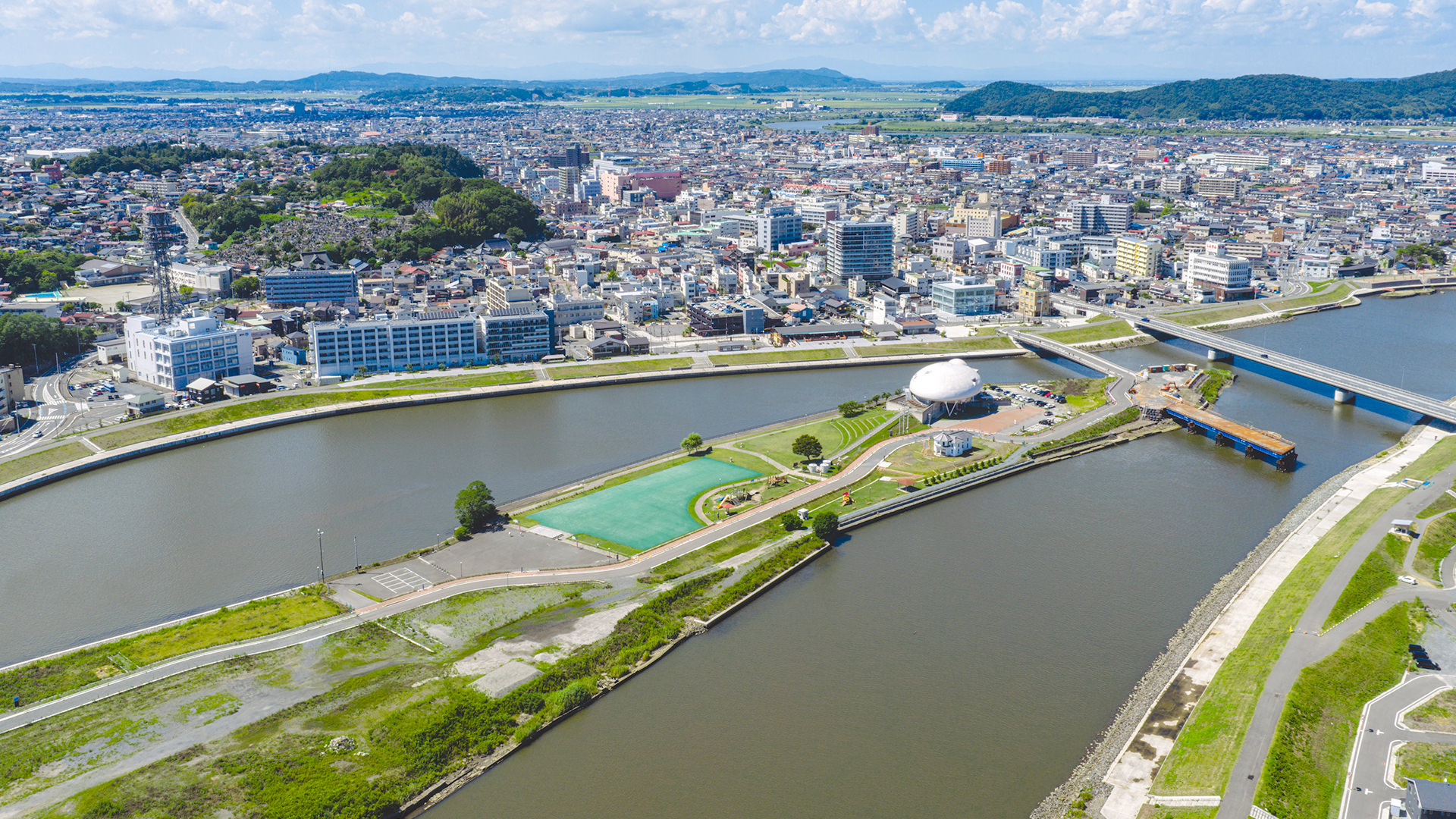
Opened to the river since the Edo period, Ishinomaki City developed initially as a town for shipping, and later as a fishing base that made use of the fishing resources of Mount Kinka and the Sanriku coast, thriving as a center for the distribution of catches and the seafood processing industry. The view of the old Kitakami River flowing leisurely before it, with the Pacific Ocean stretching out beyond its estuary, is unique to this city. A large-scale embankment structure would then be constructed there, in the busiest part of the city center. While still functioning to protect the lives and property of residents, how could it be made to blend into the riverscape and become familiar to residents? There were numerous challenges, including the basic design, building consensus among residents, and construction methods and specific construction plans that would maintain the city's functions.
The Kitakami River Downstream River Office of Ministry of Land, Infrastructure, Transport and Tourism's Tohoku Regional Development Bureau played a central role in formulating the master plan for the embankment, and Ishinomaki City also worked in conjunction with the embankment improvement plan, replacing bridges, building new drainage pumping stations, and even moving forward with a "Waterside Green Promenade Plan." This launched the "Embankment Improvement and Ishinomaki District River Town Development" project, an unprecedented project in Japan, in which the national and city governments worked together to build a large-scale new embankment in the existing city center.
Detailed explanations at residents' information sections
In late March 2011, while the Shinkansen and expressways were still closed, AMADA, who was in Tokyo, headed to Ishinomaki. PACIFIC CONSULTANTS' Tohoku Branch Office had been contracted to carry out work for the Kitakami River Downstream River Office even before the disaster, and, upon request, had immediately begun damage surveys and damage assessments after the disaster. While providing support, he also planned to draw up a basic plan for the embankment and proceed with detailed design.
"Restoration and reconstruction from the disaster cannot begin until the national government first decides on a construction plan that determines where and how large embankments are needed. We first had to consider what kind of embankments we needed and what their alignment should be," AMADA said. The city's plan for a new promenade along the waterfront and integrating the embankment's top with the adjacent park and commercial facility entrances were among the many initiatives unique to the levee construction concept, which integrates the city with the surrounding area. Even after determining the basics—the embankment's size, basic structure, and alignment—the detailed design progressed with repeated revisions and changes. Another important task in parallel with these was holding and running explanatory meetings to gain residents' consent. The plan envisioned Tsunamis and high tides occurring once every several decades to a century, so he was thinking it was necessary to construct embankments with a total length of approximately 15 kilometers on both banks, measuring 7.2 meters at their highest point and 4.5 meters at their lowest. However, for residents who have always relied on the river as a part of their daily lives, this was not an easy thing to agree to.
"There was a lot of opposition, with many citing reasons such as the river becoming invisible, the large concrete structure creating a sense of blockage, and the fact that a similarly large Tsunami wouldn't occur anytime soon. Furthermore, the construction of this embankment is large, and the assumption is that the area downstream near the estuary will be used for non-residential purposes such as factories and warehouses, meaning some residents will be asked to relocate. This also contributed to the strong resistance to the construction of the new embankment. The River Office took the lead in holding repeated explanatory meetings, and we attended all of them, providing support such as detailed explanations of the plan," says TSUKA, who accompanied AMADA to the meetings. Following the River Office's policy of providing thorough, attentive explanations to residents, the office held two or three explanatory meetings with more than 10 neighborhood associations, patiently explaining that the levee was absolutely necessary to protect the town behind the river. With each meeting, residents' understanding grew, and calls for the embankment to be constructed quickly to ensure a safe and secure neighborhood for future generations grew louder. Finally, the plan was approved in January 2013. "It's rare for us designers to have the opportunity to hear the opinions of local residents directly. It was a great learning experience, and it also motivated me to meet everyone's expectations, which motivated me to continue my work," TSUKA recalls.
Responsible for CM work
In addition to building consensus among residents, the embankment construction project faced another major challenge: The promotion of construction. Many related projects had to be carried out simultaneously in the city center. Moreover, the project involved more than 10 different entities, including the prefecture, city, and private companies.
For example, the city is promoting the construction of drainage pumping stations. Previously, rainwater simply flowed into the river, but because it is now separated by a embankment, it is more likely to accumulate. In addition, the ground in Ishinomaki City fell by about 60cm due to the earthquake, which also makes draining rainwater difficult. At the same time as the construction of the embankment, multiple new pumping stations had to be built. Furthermore, if a new embankment were to be built, bridges near the estuary that were not high enough to function properly would have had to be replaced. This work is also under the jurisdiction of the city. Furthermore, as the embankment is constructed, the roads running along the river also have to be rebuilt. This is mainly the responsibility of the prefecture. In addition, promenades, parks, and commercial facilities were also being developed in conjunction with the embankment.
"The challenge was how to coordinate the work schedules of each project and ensure smooth progress," says AMADA. "For example, if the embankment was built, the city's construction roads and bridge abutments would not be able to be installed. At the same time, we could not delay the construction of the embankment in favor of prioritizing the progress of surrounding projects. If coordination was not achieved well, there were concerns that the overall schedule would be delayed and work errors would be introduced. Furthermore, there were many project entities, each with a high level of expertise. Therefore, the national government decided to entrust the overall coordination of the project to a construction management (CM) system *3, in which a team of private engineers would be responsible for the project, and PACIFIC CONSULTANTS was chosen to handle this task."
*3 The CM method is a type of "construction production and management system," in which a construction manager (CMR), who acts as an assistant or representative of the client, performs all or part of various management tasks, such as design considerations, construction ordering methods, schedule management, and cost management, while maintaining technical neutrality and standing on the client's side (Source: "CM Method Utilization Guidelines", Ministry of Land, Infrastructure, Transport and Tourism).
Creating and managing the overall project schedule
The pumping stations, bridges, roads, and other construction work to be done around the new embankment will be the responsibility of the city and prefecture, each with their own construction schedules. Naturally, each contractor will be different. PACIFIC CONSULTANTS compiled the schedules for each project, created detailed plans to manage the entire project, detailing what should be prioritized, how the overall process would proceed, and how all construction would be completed within the originally planned timeframe. Regular meetings were held twice a month to discuss progress and issues, and individual meetings were also held as needed. Despite this, various problems arose.
"Construction delays inevitably occur due to the circumstances of each business operator. Simply asking them to complete the work as scheduled is not enough. We proactively made adjustments, such as proposing construction methods that would improve efficiency and adjusting the progress of construction on the embankment side so that temporary roads and piers could be set up for work related to the construction of the bridge and drainage pumping station. As general construction consultants, we have specialized knowledge in various fields such as bridges, roads, and architecture, so I think we were able to make use of this when proposing construction methods," TSUKA recalls.
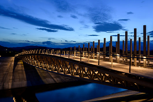
Overseeing the entire process from design to completion
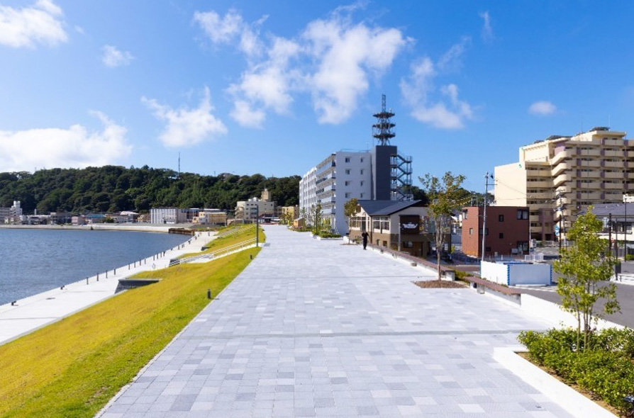
Well-maintained Embankment and Surrounding Facilities (Near the traffic plaza)
The national master plan, "Ishinomaki District River Town Development," which was implemented following a resident agreement in January 2013 and the final decision of Ishinomaki City's "Ishinomaki Waterfront Green Promenade Plan" in March 2013, was driven in large part by the adoption of the CM method, with almost all of the work completed in fiscal year 2021, and a completion ceremony was held on April 23, 2022. The construction period spanned more than 10 years in total, but many residents have visited the revitalized waterfront space integrated with the embankment and are enjoying life by Ishinomaki's new river.
(Source: Ministry of Land, Infrastructure, Transport and Tourism, Tohoku Regional Development Bureau, Kitakami River Downstream River Office "Ishinomaki River Urban Development Design Notes")
"It was a valuable experience to be involved from the damage survey immediately after the disaster, to creating the embankment design from scratch, and even to overseeing its completion while overseeing its construction," says AMADA. "It was a great learning experience to see how the drawings I drew came to fruition, and I'm proud to have been involved in such a major undertaking." AMADA is still involved in another project, building an embankment upstream of the former Kitakami River.
On the other hand, this project led TSUKA to change jobs to PACIFIC CONSULTANTS and become a full-time employee, so in that sense it is a very moving experience for him.
"At the time of the disaster, I was working on a different river-related project as a member of a subcontracting company, but in late March I was sent to PACIFIC CONSULTANTS' Tohoku Branch Office to provide supports. After being seconded there, I was transferred to PACIFIC CONSULTANTS and became a full-time employee, and I have been involved throughout the project, changing positions throughout. It is not often that you get to be involved in a project of this scale with so many stakeholders. In particular, my experience for CM work, bringing together more than 10 companies, was extremely valuable in terms of improving my management skills. The things we design are directly related to flood control and are important for protecting people's lives. They must function properly. This project allowed me to learn the finer details of construction, so I will use that knowledge in my designs and pass it on to younger employees, as I continue to work hard for the region and the country."
A single project can give birth to a new town or lifestyle, and it can also generate a variety of learning experiences that can be passed down from person to person, connecting to the future.