The "Long-Term Assessment of the Probability of Earthquakes" by the government's Headquarters for Earthquake Research Promotion predicts a high probability of a massive earthquake, and as natural disasters become more severe and frequent due to climate change, the efficiency and sophistication of disaster prevention and mitigation measures through DX are becoming an urgent issue. As an important tool for this, commercial SAR satellites are attracting attention because of their ability to observe the ground at high frequencies regardless of time of day or weather conditions. We interviewed Mr. Toshiki YANAGIMACHI, Technical Manager of the Resilience Promotion Sec., Mr. Tsukasa MITOGAWA, Assitant Manager of the Disaster Prevention DX Promotion Sec. of Disaster Prevention Dept., Digital Service Div. and Mr. Nobukazu SASAKI, General Manager of Technology Development Sec. of Advanced Technology Center of PACIFIC CONSULTANTS, who are working on satellite applications in the field of spatial information technology.
INDEX
- What is a SAR satellite? Why is it attracting attention?
- How SAR satellites work and what SAR images can tell us
- SAR satellites are expected to be utilized in the field of disaster prevention and mitigation
- Issues with using SAR satellites
- PACIFIC CONSULTANTS' Initiatives
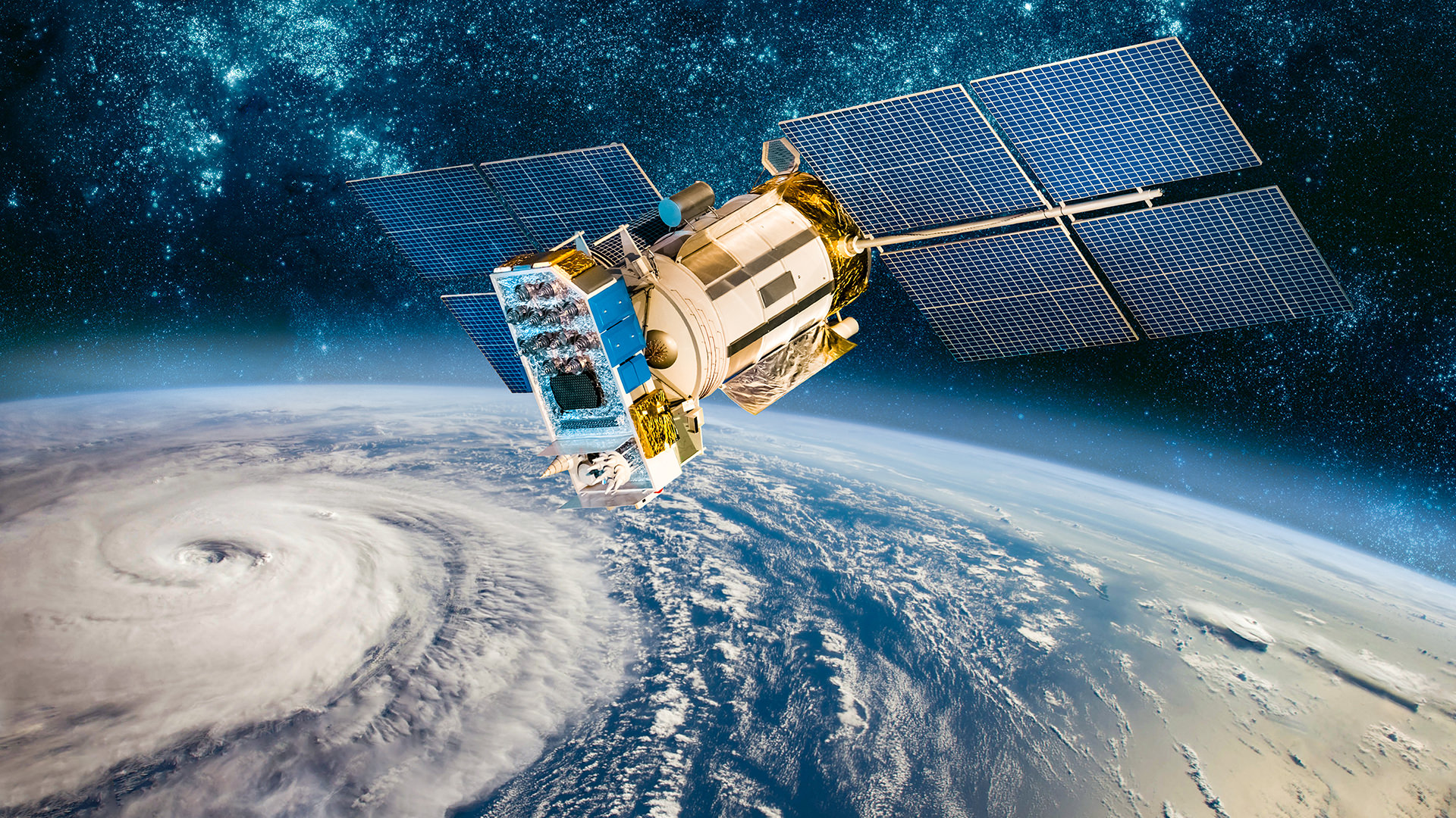
What is a SAR satellite? Why is it attracting attention?
SAR (Synthetic Aperture Radar) satellites are Earth observation satellites that radiate microwaves toward the Earth's surface and analyze the reflected waves to understand the shape and properties of the surface. Optical satellites, which capture images of the Earth's surface from sunlight reflected off objects, similar to digital camera photography, are well known. However, they cannot observe at night when sunlight is blocked or during the day when the sky is covered by clouds. SAR satellites, on the other hand, radiate microwaves that are less affected by clouds and rain, allowing them to observe the Earth's surface regardless of the time of day or weather. The observation range varies depending on the satellite, but they can be used to capture images over a wide area, such as 200 or 300 km, or conversely, narrow the range to tens or even a few kilometers for higher resolution, depending on the purpose. Furthermore, high-precision images taken at a regular interval from the same location under the same conditions can be obtained, allowing for accurate interpretation of changes over time.
Differences between SAR satellites and optical satellites
| SAR satellite | Optical satellite | |
| Observation Method | Analyzing the reflected information of microwaves emitted by itself | Visually reproduces information about sunlight reflected to an object |
| Observation Conditions | Not affected by time of day or weather | Only during good weather during the day |
| Observation Result Format | A monochrome image showing the strength of radio wave bounces. Analysis is difficult. | Full-color images that are intuitively understandable to everyone |
| What We can learn from observation | Shape and characteristics of the object, soil moisture content | Size, shape, and color of the object |
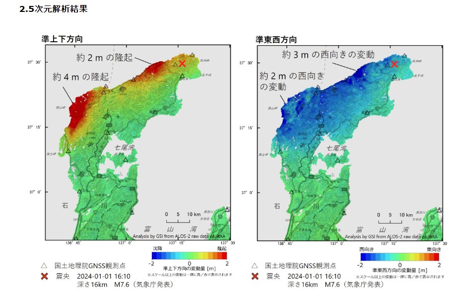
One example of the effectiveness of SAR satellites was the observations made immediately after Noto Peninsula Earthquake in January 2024. Following this earthquake, information gathering on the damage situation began immediately after the disaster, but because the disaster occurred in the evening, the survey was conducted at night, making it difficult to grasp the individual damage situations and scale of the damage using images from aircraft, etc. However, at around 11pm on the night of the disaster, JAXA's (Japan Aerospace Exploration Agency) large SAR satellite, "Daichi-2," took images of the area, and analysis of these images revealed the occurrence of a large-scale ground uplift, confirming the effectiveness of SAR satellites, which can make observations even at night.
JAXA's SAR satellites currently in operation are Daichi-2 and its successor, Daichi-4. However, these are large satellites, weighing either 2 or 3 tons, and both use a "recurrent orbit" that orbits the Earth in approximately 97 minutes and returns to the same location every 14 days. Launching and operating them requires a great deal of effort and cost, and the limited number of satellites makes it difficult to respond quickly or to make frequent observations of the same location. Satellite images are also very expensive, making them difficult for private companies to easily use.
However, since the mid-2010s, rapid technological development has made it possible to reduce the size and weight of SAR satellites to around 100 kg, allowing private companies to launch and operate them at low cost. Currently, a number of Japanese startup companies are operating a total of nearly 10 SAR satellites. At the same time, the introduction of AI and other technologies has dramatically improved image analysis technology, making it possible to obtain high-quality SAR satellite images more cheaply and at a frequency of one or two images per day. Currently, "satellite constellations," which operate multiple small satellites in cooperation with each other, are making progress in utilizing technology to observe every region of the Earth at high frequency, and SAR satellites are poised to become a leading Earth observation tool in the future.
How SAR satellites work and what SAR images can tell us
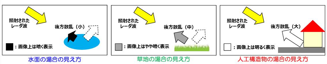
SAR satellites understand the surface condition of an object by the strength of the reflection of microwaves irradiated onto it. The return of microwaves in the direction of their irradiation is called "backscattering." Backscattering is strong in areas with many obstacles and unevenness, such as forests and urban areas, and appears bright (white) on SAR images. Conversely, on smooth surfaces such as the ocean, most of the light is reflected forward, resulting in weak backscattering and making the image dark. The magnitude of backscattering is also affected by the condition of the ground surface, the presence and type and material of objects, and the amount of soil moisture. By analyzing these differences in scattering characteristics, it is possible to estimate the situation and changes on the ground.
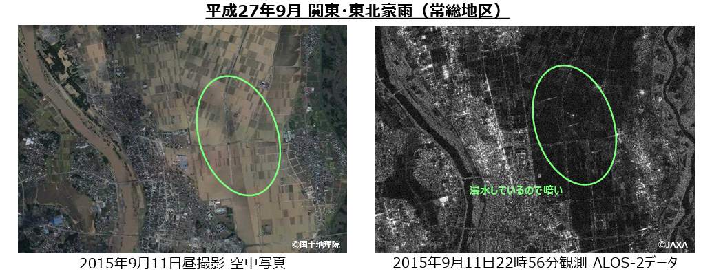
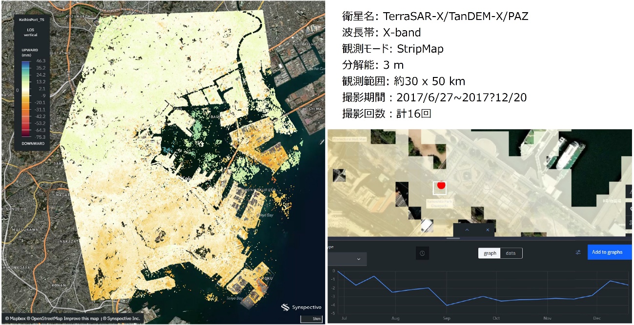
In addition, by analyzing the difference in observation data before and after a disaster, it is possible to grasp the extent of inundation caused by tsunamis and floods, and by analyzing observation data from multiple periods, it is possible to grasp, in units of a few centimeters to a few millimeters, ground subsidence, the settlement of concrete structures such as levees, revetments and dams, horizontal movement due to the influence of earth pressure behind them, etc. Previously, to accurately grasp such ground movement and changes in structures, it was necessary to go to the site and conduct surveys manually.
However, SAR satellites can obtain information over a wide area with uniform accuracy and periodicity without having to enter the site. For this reason, it is expected to be used in the following ways:
<Monitoring crustal movements, land subsidence, volcanic activity, etc.>
Understanding movements such as crustal movements, subsidence, and the expansion and uplift of active volcanoes, and detecting signs of eruptions
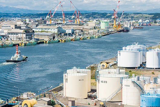
<Maintenance, inspection, and management of roads and structures>
Detect changes, distortions, and tilts in concrete structures such as roads, dams, and levees, as well as bridges
<Understanding damage during disasters>
Grasp the damage caused by earthquakes, typhoons, floods, etc.
<Resource management such as forestry and monitoring environmental destruction>
To understand the growth status of agricultural crops and forests, and to monitor illegal logging
SAR satellites are expected to be utilized in the field of disaster prevention and mitigation
SAR satellites are expected to play a particularly important role in the field of disaster prevention and mitigation.
When a disaster occurs, it is necessary to quickly and accurately assess the extent of the damage in order to determine whether social infrastructure can be used, provide emergency medical assistance, issue evacuation instructions and guidance, open evacuation shelters, and transport evacuation supplies. However, information gathering is often limited by factors such as time, weather, road closures due to collapsed buildings, and limited manpower. In such cases, SAR satellites can be used to observe a wide area and grasp the extent of the damage. Analyzing this observation data allows for the rapid compilation of damage status immediately after a disaster, narrowing the scope of helicopter and ground surveys, formulating mobilization plans, calculating the required amount of drainage from the estimated flooded area, and considering drainage pump placement plans.
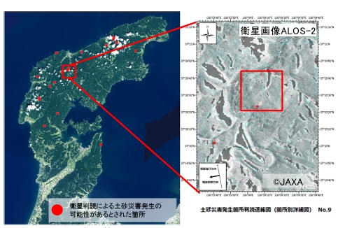
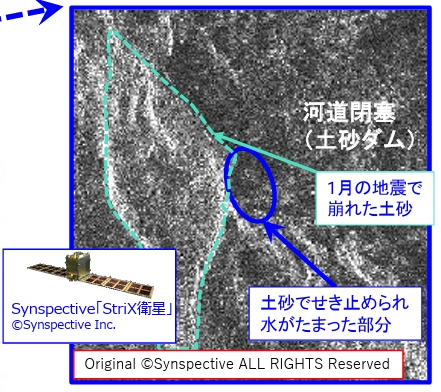
In fact, as mentioned earlier, the occurrence of large-scale ground uplift was detected during Noto Peninsula Earthquake in January 2024, and the system was also effective in identifying areas where large-scale landslides were likely to occur during the heavy rain disaster that occurred a few months later.
Source: "Measures for flood and landslide disasters in light of earthquakes and heavy rains on the Noto Peninsula" (November 2024) (Central Disaster Prevention Council, Disaster Prevention Measures Implementation Committee)
Furthermore, in order to minimize the risk of compound disasters such as those seen in the Noto Peninsula disaster, it is necessary to understand the risk of subsequent disasters based on the scale of damage caused by preceding disasters and consider emergency measures. Even in such cases, if a certain level of risk assessment can be performed by analyzing SAR satellite images, it will be possible to take measures to prevent compound disasters in parallel with responding immediately after the preceding disaster.
Source: "Recent Trends in Space Policy," Cabinet Office's Space Development Strategy Promotion Secretariat (September 2025) (Cabinet Office)
Issues with using SAR satellites
While the effectiveness of surface observation by SAR satellites has been demonstrated, several issues have also become apparent. For example, the accuracy of satellite image analysis. Decisions regarding disaster response require accuracy, as limited human resources must be allocated effectively. To that end, improving the accuracy of image analysis is a major theme, and knowledge must be accumulated in various ways, such as by comparing actual wind and flood damage events with satellite image analysis data.
However, no matter how much the resolution is increased and the accuracy of data analysis is improved, it is impossible to obtain information from SAR satellite images with the same level of accuracy as photographs taken at low altitudes using airplanes or drones, or by people actually surveying and measuring on-site. This is why it is necessary to collect spatial information at various levels, with SAR satellite images as a part of it, and make a comprehensive judgment.
There are various means for grasping spatial information, ranging from wide-area, low-resolution data acquisition using satellites and aircraft to narrow-area, high-resolution data acquisition using drones, vehicles, and ground-based sensors. By utilizing these methods based on their characteristics and integrating the information obtained, it becomes possible to collect information tailored to specific purposes, such as infrastructure management and disaster prevention and mitigation. In this sense, observation of the earth's surface by SAR satellites has the advantage of being able to collect wide-area information quickly and efficiently, regardless of time or weather, immediately after a disaster occurs. In other words, it is highly valuable as primary information for improving the accuracy and appropriateness of disaster response efforts after a disaster occurs.
By combining a variety of technologies and information, such as images taken by large SAR satellites operated by the government (JAXA), SAR satellite images provided by private business sectors, information from the air using aircraft and UAVs (Unmanned Aerial Vehicles), and ground surveying, and integrating the results, it becomes possible to obtain information that is effective for disaster prevention and mitigation.With so many tools available, it is important to properly manage the various spatial information technologies, determining at what stage and how to combine them for effective use.
| Wide area/Low resolution | |
| ・Artificial satellite (Optical/SAR) ・Aircraft (Planes, helicopters) ・UAV (Fixed wing, drone) ・Vehicles and ships ・Ground-mounted sensors ・ROV, USV, and other underwater and surface measurement equipment |
|
| Narrow band/high resolution Special place |
PACIFIC CONSULTANTS' Initiatives
PACIFIC CONSULTANTS, which has been engaged in a variety of initiatives in the field of spatial information technology, recognized the potential of next-generation SAR satellites early on and formed a business partnership with Synspective Inc. in 2021. The company aims to operate around 30 SAR satellites by the late 2020s, enabling it to provide images anywhere in the world within an hour, which is expected to become a powerful means of gathering information, such as for understanding the extent of damage caused by disasters. Currently, PACIFIC CONSULTANTS and Synspective Inc. are conducting trial observation and analysis of major disasters that have occurred both domestically and internationally, and are conducting research and development from various perspectives, such as improving the accuracy of observations and the speed of delivery of analysis results using SAR satellites, as well as considering continuous use cases.
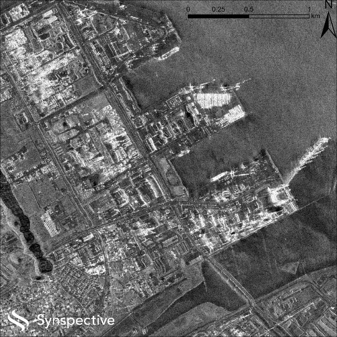
Image taken at 14:31 on December 9, 2025, after the Aomori Prefecture East Offshore Earthquake 2025 (Mj7.5) that occurred around 23:15 on December 8, 2025, with a resolution of approximately 1m.
Through this partnership, we will further strengthen our field of spatial information technology, not only by collecting information and providing analytical data using SAR satellites, but also by utilizing this data to enhance and strengthen our consulting services related to disaster prevention and recovery and reconstruction after disasters.
The acquisition and analysis of SAR satellite images is extremely useful in a variety of fields, including roads, ground, ports and harbors, coasts, rivers, erosion control, and railways, from detecting minute changes during normal times to quickly grasping the situation in the event of a disaster and identifying the risk of secondary and complex disasters. By deepening our knowledge not only of SAR satellites but also of the analysis of optical satellite images, and integrating this with spatial information technologies such as measurement and observation using aircraft and UAVs, we strive to improve the sophistication of consulting services suited to the type of infrastructure and the scale of the disaster, contributing to the digitalization of disaster prevention and mitigation measures, as well as to making them more efficient and sophisticated.